This data-file estimates drone inspection costs, for the construction and resources industries, using bottom-up numbers from technical papers.
Drones can be used to inspection mining, construction, LNG or forestry activities, in order to survey activity and identify issues. Many of these drones are electricity and are inherently easier to decarbonize than combustion-powered transportation.
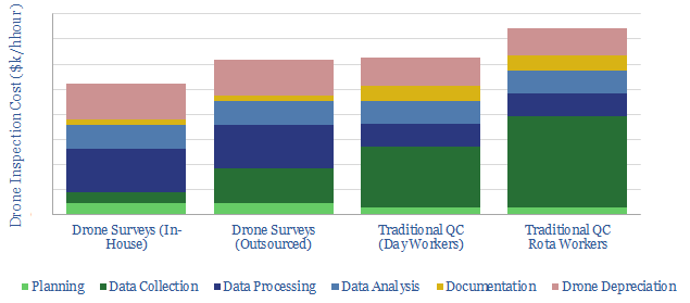
When using drones for inspections, costs per hour can be 30% lower than for traditional quality control inspections. A single drone, including software licenses likely costs c$30k, which is disaggregated line-by-line in the data-file.
The data-file also quantifies the capabilities of drones to monitor carbon accumulation in forests, capturing the details of ten technical paper from the past decade, which used LiDAR to measure DBH (below).
The average drone-LiDAR study in 2011-2022 is capable of identifying 80% of the trees and captures their diameter with a +/- 15% margin of error. As cool as this is, it is not quite good enough (yet) to quantify carbon stocks. Although the survey may be 30% lower than traditional approaches.
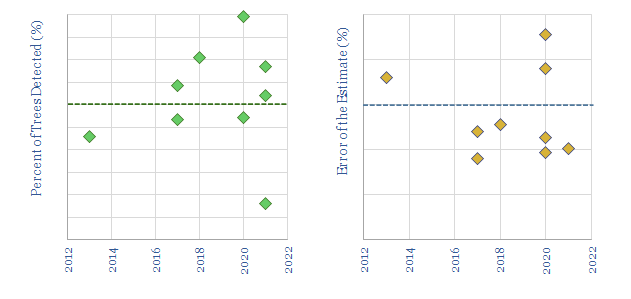
And this is still quite generous. Some of the “better” studies are flying through stands that have already been mapped, stands near clearings, in mono-culture pine forests, or in the dead of winter (i.e., these are not real, biodiverse forests with leaves obscuring the field of view).
Our notes in drone inspection costs and notes from related technical papers are also included in the data-file. A screen of drone companies is linked here and our other research into drones in the energy transition is linked here.