Global mean sea levels will rise materially by 2100, irrespective of future emissions pathways. This note contains our top ten facts for decision makers, covering the numbers, the negative consequences and the potential mitigation opportunities.
(1) Sea levels are rising, at an accelerating pace. Global mean sea levels increased by 1.4mmpa from 1901-1990, 2.1mmpa from 1970-2015, 3.2mmpa from 1993-2015 and 3.6mmpa from 2006-2015. We know this from satellite altimetry measurements, which are highly accurate and started in 1992; while older data are derived from tidal gauges and are less accurate. c40% of the recent increase is due to the thermal expansion of water as global temperatures rise, and c60% is mass gain from melting ice caps and glaciers.
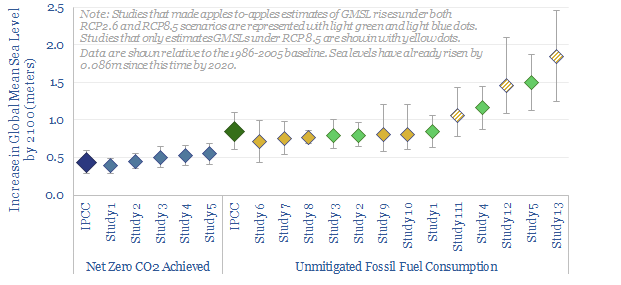
(2) Sea levels are expected to rise by 0.84m by 2100 versus the 1986-2005 baseline, if global CO2 emissions keep rising and we fail to achieve an energy transition (i.e., this is the base case expected under the IPCC’s RCP 8.5 Scenario). This is driven by a continued acceleration of annual sea level rises, to 10-15 mm per year by 2100.
(3) Sea level could rise by as much as 2.5m by 2100 in the most pessimistic studies we have seen (chart below). The uncertainty between studies arises because of feedback loops that are difficult to model. For example, rising sea levels deform the Earth’s lithosphere and subtly alter the Earth’s rotation and gravitational field; we also know 90% of global warming ultimately gets stored in the oceans, but the degree of thermal expansion depends on precisely where the heat ends up being distributed.
(4) Sea levels could rise by >10m by 2500. The IPCC states that gross mean sea levels will “continue to rise for centuries” after 2100, due to lag effects in the deep ocean and in ice melt. As historical precedents, gross mean sea levels were 6-9m higher in the Last Interglacial period, 129-116ka ago, when temperatures were 0.5–1.0ºC warmer than today; and up to 6-30m higher during the mid-Pliocene Warm Period, 3.3-3.0Ma, when temperatures were 2–4ºC warmer than today. Total potential sea level rises are much larger again: The Antarctic “ice cap” covers 14M sq km, contains 26.5M cubic kilometers of ice, and would raise sea levels by 58m if it melted entirely. But modelling the long-term future of the Ice Caps remains controversial. In 2015, NASA published data showing the Antarctic Ice sheet was actually still gaining mass, as warmer air was carrying in more moisture and depositing more snowfall on the Continent, which is presently outweighing melt losses at the edge of the Western Antarctic Ice Sheet. The IPCC disagree with NASA. The University of California also finds that melt rates on the WAIS are accelerating, from 40GTpa in the 1980s to 250GTpa in the 2010s (here).
(5) Sea levels will still rise even if we reach ‘Net Zero’. A goal in our research is to find economic opportunities that can help meet the world’s energy needs while reaching ‘net zero’ CO2 by 2050 (models below), while limiting atmospheric CO2 to 450 ppm (also below). But even if we do this, sea levels are still expected to rise by 0.43m by 2100, and continue rising thereafter, due to the same lag effects described above. 0.43m by 2100 is the latest official estimate from the IPCC, but academic estimates range from 0.3-0.7m. This is an important and surprising conclusion. All of the Herculean efforts, policy measures and novel technologies being considered today will not avert sea level rise. They will merely slow it down.
(6) Regional variations. Sea level rises are not the same everywhere. For example, Scandinavia, Northern Europe and the US Great Lakes region are still decompressing from the last Ice Age, 11,000 years ago. With the weight of these former glaciers removed, they are rising between 3-9mm per year through the process of ‘isostatic rebound’. Conversely, the US East Coast is subsiding, by c2mm per year, as it was previously a ‘glacial forebulge’, lifted up by the weight of ice pressing down on lands to the West. The steepest subsidence is in areas of rapid groundwater extraction to irrigate marginal lands. For example, much of the Nile Delta is subsiding at 0.4-3.4mm per year.
(7) Danger zones. Low lying areas are going to be inundated with rising sea levels within our lifetimes, irrespective of how the world’s energy system changes. Some of us run DCFs that go out to 2050 or even 2100. Some of us are also making decisions whose lasting impacts will stretch 30-80 years into the future. If you wish to consider the impacts of rising sea levels, then there are excellent online mapping tools such as Surging Seas showing how coastlines are expected to change over time.
(8) Negative consequences? To state the obvious, homes are prone to becoming unlivable and industrial assets are prone to becoming inoperable when they are suddenly underwater. High tides will become higher. Storm surges will reach further inland. Thus, annual flood damages are expected to be 2–3 orders of magnitude higher by 2100 (Hurricane Sandy (2012, $19bn of damage) and Typhoon Winnie (1997, $3.2bn damage) are already considered the largest recorded historical flood events for New York and Shanghai, respectively). In low-lying Bangladesh, oilseed, sugarcane and jute cultivation has now stopped as rising salinity levels have impaired growing conditions. Similarly, the Nile supports 40% of Egypt’s population, but large portions are only 1.5m above sea level, subsidence is running at 0.4-3.4mmpa, and salinisation will trouble traditional agriculture. This evokes fears over very large ‘displaced populations’.
(9) Large-scale coastal defences. New York City recently considered spending $119bn on a giant concrete Sea Wall, which would span 6-miles from the Rockaways in Queens, across New York Harbor, to New Jersey (the price tag is equivalent to $15k per New Yorker). Miami is also spending $2M per block to raise its roads by 2-ft. This measure needs to be combined with stormwater pumps, to ensure the roads do not channel flood waters into buildings at lower elevations. One wonders whether a vast new market will emerge for construction materials and aggregates in coastal defences (e.g., Vulcan Materials, Martin Marietta). But there is also something woefully circular about using carbon-emitting building materials (1 ton of cement emits 1 ton of CO2, charts below) to alleviate the negative consequences of CO2 emissions.
(10) Nature based solutions? Blue carbon ecosystems, such as mangroves (13.8-15.2M ha), salt marshes (2.2-40M ha) and sea grasses (17.7-60M ha) make up 2% of the total ocean area, but 50% of the total carbon sequestered in ocean sediments (here). Studies have found that mudflats and interior mangroves can accrete 4-10mm per year of elevation (here), which could help counteract rising sea levels. 30 mangrove trees per square meter can also reduce the maximum flow of surge tides by 90%, studies have found, and areas with dense mangrove cover were less affected by the 2004 Boxing Day tsunami. Those who follow our research will also know we have found nature based solutions, such as planting trees, to be among the most cost-effective ways to offset CO2 emissions. Companies including Danone, Apple, Henkel, Toyota and a French consortium have thus started planting vast numbers of mangroves as part of their environmental protection programs. Charities such as Eden Reforestation, One Tree Planted and Sea Trees offer similar opportunities for individuals.
Sources, Acronyms & Terms
Oppenheimer, M., B.C. Glavovic , J. Hinkel, R. van de Wal, A.K. Magnan, A. Abd-Elgawad, R. Cai, M. Cifuentes-Jara, R.M. DeConto, T. Ghosh, J. Hay, F. Isla, B. Marzeion, B. Meyssignac, and Z. Sebesvari. (2019). Sea Level Rise and Implications for Low-Lying Islands, Coasts and Communities. In: IPCC Special Report on the Ocean and Cryosphere in a Changing Climate.
GMSL = global mean sea level, on average, smoothing waves, surges and tides
RSL = relative sea level rises.
ESL = extreme sea level events
RCP = Representative Concentration Pathway emissions scenario.
RCP2.6 assumes Net Zero in the late 21st century and <2C of warming.
RCP8.5 is a ‘worst case scenario’ where emissions keep rising to 2100.
GIS = the Greenland Ice Sheet
AIS = the Antarctic Ice Sheet
SMB = surface mass balance, the gain or loss of ice from ice sheets
Ice Shelves = the floating extensions of grounded ice flowing into oceans